Sunday, February 25, 2007

Thoughts_Furthering Builiding as Landscape

in response to some the the earlier mappings that we produced, we set out create a set of parameters that would serve to define the site. we first redefined the ground plane, applying the mesh that we generated as the base landscape. we then applied the building heights mesh as the maximum building envelope. we also decided to place all the building on the original ground plane. we placed the museum as we had in our previous scheme. we also proposed two small ribbons that would undulate through the site along the building heights mesh in order to indicate the scale of the buildings that once existed on the site.


img_1.0 - plan


img_1.2 - perspective


img_1.3 - perspective


img_1.4 - front elevation


img_1.5 - section. note building heights grid ghosted in background

Monday, February 19, 2007

Thoughts_Site Mapping

following our last review, we decided to take a step back and do some site mappings to solidify some of our inclinations about siting and form. we were particularly interested in three components:
  1. building heights - the scale of the buildings that existed on the site dictated its experience
  2. historic palimpsest - the 'historic density' in various areas of the site
  3. rail lines - these lines dictate the movement of goods throughout the site
we used a vertical displacement mesh to map the building heights and historic density. we then extruded all the rail lines and used these to cut the two meshes.


img_1.1 - the residual of the rail lines. high points indicate where rail lines were closely tied to a manufacturing process.


img_1.2 - the same map as above with the building height and historic density meshes shown

Sunday, February 18, 2007

Thoughts_3D Grid

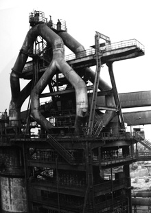
Here are some quick studies developed using a three dimensional grid; one axis corresponds to the sharp edges of the historical buildings (x-axis), another begins straight, but molds itself to the curved bank of the river (y-axis), and the last responds both to the monumental scale of the Carrie Furnace buildings and to the scale of a human body (z-axis). The x and y axis are tubular interlocking splines and z axis is a series of rectangular planes engulfing the entire historical Carrie Furnace site. The study may lead to some architectural elements as it is further refined, but for now, the scale of the grid overpowers the program intensely.


1.1_view from ground plane through grid


1.2_grid as viewed from above, looking in the direction of the Carrie Furnace